It’s Finally Raining

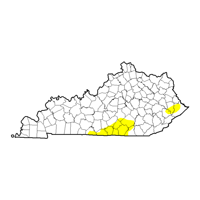
After a very dry past few months, the Ohio Valley is finally getting a good soaking rain. The drought is not over by any means; however, at this point every drop counts. As of last week, almost the entire state of Kentucky was in a severe drought. Extreme drought conditions are even showing up in southern portions of the state. It has been quite sometime since this area has been in a drought of this intensity and it’s going to take multiple storm systems like this one to put a dent in it.

The map below from the US Drought Monitor shows the extent of the drought in Kentucky.

20161122_ky_none

So far today 1-2″ of rain has fallen across Western and Central Kentucky and Indiana. Tomorrow night more rain is in the forecast across the eastern portions of Kentucky, where the drought is the worst.

The current radar below from the National Weather Service shows rain engulfing much of the Ohio Valley and Great Lakes. This rain will move eastward through the night giving way to much drier conditions during the day on Tuesday.

centgrtlakes_loop.gif

Tuesday for the most part will be a very nice day across the region with southerly winds and temps well into the 60s. Unfortunately, the nice weather won’t last long as the main cold front will move though late Tuesday night into Wednesday morning bringing with it colder air and more rain. The map below is from the NAM4K model showing rain along and east of the I-65 corridor tomorrow night. This area has the best chance of getting a good soaking rain. Areas west of I-65, especially in Indiana will be much drier and could escape the rain completely.

nam4k112916

Once the front clears the region early Wednesday morning, much drier air will move in allowing clouds to begin to break. The cold air will be lagging behind a bit which means Wednesday afternoon may turn out very nice with temps in the upper 50s to low 60s. The cold air will reach the Ohio Valley Wednesday night allowing temps to fall into the 20s for lows and 40s for highs the rest of the week.

Weekend and Next Week

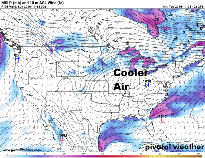
The weekend looks to start out cold and dry; however, some weather models are showing a southern storm system that could impact the region sometime Sunday and into early next week. Right now none of the models for this time period agree on what will happen as some show dry, sunny weather and some show rain. This will be an interesting system to watch over the next couple of days. More updates to come as the weekend gets closer.


Forecast

Tuesday: partly cloudy skies. Rain developing late. Lows in the upper 40s to low 50s. Highs in the mid to upper 60s.

Wednesday: morning rain moving east throughout the day. Lows in the upper 40s to low 50s. Highs in the upper 50s to low 60s.

Thursday: mostly sunny skies. Lows in the mid to upper 30s. Highs in the mid to upper 40s.

Friday: mostly sunny skies. Lows in the upper 20s to low 30s. Highs in the mid to upper 40s.

Saturday: partly cloudy skies. Lows in the mid 20s to near 30. Highs in the mid 40s.

Sunday: mostly cloudy skies. Scattered showers. Lows in the low to mid 30s. Highs in the mid 40s.

Monday: mostly cloudy skies. Scattered showers. Lows in the upper 30s. Highs in the mid 40s.


Drought Conditions Continue

Fall 2016 has featured nothing but extremes; record setting temps in October and now bone dry conditions in November. The warm, dry weather looks to continue through the rest of the week with a chance for some much needed rain Friday night.

Here is a look at a few maps from the US Drought Monitor showing almost all of Kentucky experiencing drought conditions and even parts of Southern Indiana.

  • Yellow: Abnormally Dry
  • Light Brown: Moderate Drought
  • Orange: Severe Drought

20161108_ky_none20161108_in_none


Overall the weather this past week has been typical of Mid-November with cold frosty mornings and mild afternoons. This week will be even warmer with temperatures nearing record territory again by Friday. The map below from the SPC shows a trough of low pressure over the Eastern US while a ridge of high pressure is over the West. This ridge will move over the Ohio Valley during the next couple days allowing warmer air to engulf the region. On  top of the warmer temps, winds will be on the gusty side creating perfect conditions for fire weather Thursday and Friday. The local National Weather Service Websites will give more information on where and when burn bans will be in place.

300mb

By Friday Night a cold front will pass through the region bringing an end to the short Indian Summer. Strong scattered thunderstorms are not out of the question Friday night, especially in Western Kentucky and Indiana. The rain will be much needed though.This will not eradicate drought conditions; however every little bit of rain helps and will temporarily reduce wild fire dangers. After the front passes through, the bottom drops out as high temps will plummet into the 40s/low50s for the weekend and into early next week! Enjoy the warm weather while it’s here.


Forecast

Tuesday: Mostly cloudy skies early, clearing out late.Highs in the low to mid 60s.

Wednesday: Mostly sunny skies. Lows in the upper 30s to low 40s. Highs in the mid 60s.

Thursday: Sunny skies. Lows in the low to mid 40s. Highs in the low to mid 70s.

Friday: Mostly sunny skies. Isolated storms later in the evening. Lows in the low 50s. Highs nearing record territory in thee low to mid 70s.

Saturday: Partly to mostly cloudy. Isolated shower possible. Temps in the mid to upper 40s.

Sunday: Mostly sunny skies. Cold. Hard freeze likely. Lows in the mid to upper 20s. Highs in the mid to upper 40s.

Monday: Sunny skies. Cold. Lows in the mid to upper 20s. Highs in the mid to upper 40s.

Leaves aren’t the only thing falling

It’s election day! So go out and vote! But before heading out the door make sure to bring a light jacket and an umbrella as showers will be moving through the region for the rest of the day.

Unfortunately, the cooler weather is here to stay. The first week of November started out with record warmth; however the leaves won’t be the only thing falling over the next week. The forecast calls for the coolest temperatures of the season so far. That isn’t saying much as the “cold” air will drop temps down to around where they should be for this time of year. Let’s take a look at the set up for the next week.

Today

Currently a cold front stretching from Canada all the way down to Missouri is making its way through Indiana. This front is the reason for the rain today. After the front pushes through the region, high pressure will take over drying things out for the next week. The map below from the SPC shows the front moving through the area with a large area of high pressure behind it.

110816

This map below from Weather Underground shows rain moving through the area.The first batch of rain in Kentucky is mainly light rain and should not cause too many issues. The main band of rain in Indiana will slowly sag south and eastward throughout the day. This band is where the steadier rain is located and could cause slow delays around rush hour.

dayton-ohio-region-current-radar-animation


Wednesday – Weekend

Once the front pushes through high pressure will take over bringing with it drier but cooler weather. The map below from Pivotal Weather shows the GFS forecast for Saturday. A high pressure system right over the Ohio Valley means skies will be clear, winds will be calm and the atmosphere will be very dry. This set up will cause temps to drop below freezing in the mornings for almost everyone for the first time this season. Highs will be pretty chilly too struggling to reach 60 this weekend.

GFSmidnov.png

Another major story this fall is the drought conditions. These little rain events once a week are not doing much to help the ongoing drought across the Ohio Valley. The recent update from the US Drought Monitor (map below) shows over 81 percent of the state of Kentucky in a moderate drought compared to only 24 percent on October 25th. With dry conditions in the forecast and drought conditions becoming worse, wildfires may become an issue. Be careful when burning leaves this fall as fires will be able to spread easier and faster with all of the dry vegetation around.

20161101_ky_none


Forecast

Tuesday: Scattered showers. Temps in the 60s.

Wednesday: Skies clearing. Lows in the mid 40s. Highs in the upper 50s to near 60.

Thursday: Sunny skies. Morning frost possible. Lows in the mid to upper 30s. Highs in the low to mid 60s.

Friday: Sunny skies. Lows in the upper 30s to lower 40s. Highs in the low 60s.

Saturday: Sunny skies. Lows in the low to mid 30s. Widespread frost and freezing conditions possible. Cool. Highs in the mid 50s.

Sunday: Sunny Skies. Hard Freeze possible. Lows in the upper 20s to low 30s. Highs in the upper 50s to low 60s.

Monday: Sunny. Lows in the mid 30s to near 40. Highs in the low 60s.


Record Warm Start to November

November is starting out quite hot around the Ohio Valley right after an end to the warmest October on record for Louisville, Ky! The 116 year old record was official broken as the average temperature for the whole month reached 66.2 degrees; 6.7 degrees above normal. More records are in jeopardy this month.

Two records were broken for the first of November. The all time record high for the month of November of 84 degrees set back in 1958 and the record high for November 1st of 83 set back in 1987 were both broke today. The temp at Louisville International Airport rose to 85 degrees! The heat will continue into tomorrow where another record could be broken.

Here is the set up responsible for the record heat around the region. The map below from the SPC shows a large ridge of high pressure over the south eastern United States. Record warm temps and sunny skies can be found under this ridge.

110116-300mb

This ridge will stick around for another day before the storm system in the west approaches bringing cooler weather and the chance for storms. After another record warm afternoon on Wednesday in the low 80s, clouds will begin to increase Wednesday evening. By early Thursday morning s front will push through the region bringing a chance for rain and a few rumbles of thunder. The NAM4k below shows a forecast of the radar early Thursday morning showing scattered rain showers throughout the region.

11032016 NAM4k.png

After the front pushes through nice weather will return from Friday through the middle of next week. Temps will be a lot cooler to start out the weekend with highs struggling to reach 60 Friday. By early next week temps will be back into the lower 70s. Overall, not a bad weekend in the forecast!

Unfortunately the Ohio Valley really does need more rain. Drought conditions continue to be widespread across Kentucky and will continue to get worse if a big rain event doesn’t happen soon. As of now no big rain events are in the forecast. The map below from the US Drought Monitor shows most of the state of Kentucky in then abnormally dry category while much of South and Eastern Kentucky is in a severe drought.

20161025_ky_none

Forecast:

Wednesday: Am sun, clouds increasing in the afternoon. Lows in the mid to upper 50s. Highs nearing record levels in the low 80s.

Thursday: Am showers, pm partly to mostly cloudy. Lows in the upper 50s. Highs in the mid 60s to near 70.

Friday: Mostly sunny skies. Lows in the upper 30s to low 40ws. Patchy frost possible in cool spots. Highs in the upper 50s to low 60s.

Saturday: Sunny skies. Lows in the mid 30s to near 40. Patchy frost possible. Highs in the low 60s.

Sunday: Sunny skies. Lows in the lower 40s. Highs in the mid to upper 60s.

Monday: Sunny skies. Lows in the low to mid 40s. Highs in the mid 60s to near 70.


Warmest October on Record?

It is safe to say that 2016 has been a warm one! In fact, three months this year already have made it into the record books. March 2016 was the 8th warmest March on record since records began in Louisville in the 1870s.  This August was the 9th hottest August on record and September was the 6th hottest on record. By the look of things, October 2016 could fall into the top 3 warmest Octobers on record for the Ohio Valley. The forecast over the next week and into Halloween will feature above average temps and mostly dry conditions. We’ll break the week’s forecast down below.

Currents

Today a high pressure system way to the north and a low pressure system off to the west is putting the Ohio Valley in a great spot for some gorgeous fall weather over the next couple days. This morning started out chilly with mid to upper 30’s in many locations. Temperatures have since rebounded into the low to mid 60s in the east and upper 60s to near 70 farther west towards Bowling Green, Ky. The map below from the SPC shows the current set up.

pmsl

Tomorrow 

By tomorrow, the entire region will be in a southerly flow ahead of the low pressure system that will skirt by to our north early Thursday morning. Wednesday will feel more like summer than mid fall. Temps and humidity will be on the rise. Highs everywhere should top 70. Southern and Western Kentucky may even flirt with 80!

Late Wednesday night into early Thursday morning, that system to our north will push a weakening front through the region. Scattered showers and maybe a rumble of thunder or two will move through with the front. Southern Indiana and Northern Kentucky stand the best chance of seeing any activity. Farther south showers and storms will be more isolated. The simulated radar below from the NAM4K model shows this well.

nam4k.png

Unfortunately, the Ohio Valley does need the rain. The current map below from the US Drought Monitor shows a drought beginning to set in across the entire state of Kentucky. In fact, as of 10/18, 21% of the state is now in a severe drought (light brown) compared to only 6% on 10/11.

us-drought-101816

That map is a little scary,especially since there does not seem to be much relief in sight, even in the long term.

Speaking of scary, let’s talk about the Halloween forecast for everyone planning on dressing up and going trick or treating. As of now Halloween looks to be very nice with highs in the upper 60s and lower 70’s around the region with dry conditions! Keep in mind this forecast is a week out and could change. But for now, the weather looks perfect!

Here are some past Halloween weather facts for other weather nerds out there provided by the NWS Louisville.

Snowiest: Trace (flurries) in 1993, 1954, and 1930

Deepest Snow Cover: Trace in 1993 Wettest: 1.68” in 1941

Warmest Temperature: 84 in 1950

Warmest Daily Average Temperature: 71.5 in 1900

Coldest Temperature: 26 in 1887

Coldest Daily Average Temperature: 34.5 in 1925


Forecast: 

Tuesday: Mostly sunny skies. Highs in the mid 60’s in the east to near 70 in the west.

Wednesday: Mostly sunny skies. Clouds increasing later in the day. Lows in the low to mid 40s. Highs in the low to mid 70’s. Near 80 across the south.

Thursday: Early morning showers, then drying out in the afternoon. Lows in the mid to upper 50s. Highs in the mid 60s.

Friday: Sunny skies. Lows in the low to mid 40s. Highs in the mid to upper 60s.

Saturday: Partly Cloudy skies. Scattered shower possible. Lows in the low to mid 50s. Highs in the low to mid 70s.

Sunday: Mostly sunny skies. Lows in the upper 40s to low 50s. Highs in the upper 60s to lower 70s.

Halloween: Mostly sunny skies. Lows in the mid to upper 40s. Highs in the mid to upper 60s to near 70.

Big Cool Down Coming

Mother Nature does not want to let go of summer. After one of the warmest Septembers on record, October is shaping up to be another record warm month as well. Unfortunately for everyone enjoys the warm weather, a cool down is in the forecast. The near record setting heat will be coming to an end soon as a front moves through the area tomorrow. Lets break down the set up for this week.

Today through Thursday

The map below from the Storm Prediction Center (SPC) shows the set up for today. A system well to our north has a cold front extended south and west from it. The Ohio Valley is south of that front which means today we will have more hot, summer-like temps, southerly winds, and dry conditions. But as that front pushes closer to the area tomorrow, temps will drop and rain chances will increase.

pmsl101816

On Wednesday, that front will head southward and stall over the region. This stalled out front will cause an increase in clouds later tonight and into the day tomorrow.

Southern Indiana has the best chance of seeing more clouds and scattered showers and storms tonight and tomorrow as they are closer to the front. The whole day should not be a washout though. Temps for Indiana should be in the mid to upper 70s for highs Wednesday.

Isolated showers and storms are possible in Kentucky on Wednesday, but less wide spread than in Southern Indiana. More sun will be found in Southern Kentucky where temps should rise well into the 80s again. Northern Kentucky should expect temps in the upper 70s to low 80s.

Not only will the chance for showers increase over the next 48 hours, but the chance for strong storms with wind gusts over 58mph and small hail. The SPC has the Ohio Valley in a marginal risk (5%) for severe storms as shown in the map below. Most storms will stay below severe limits; however a few may be on the strong to severe side. Overall, not a huge concern. The best chance for severe weather will be to the west in Missouri and Arkansas. The rain and cooler temps will be the main focus for this region.

spc101916

By Wednesday night a low pressure system will form along the front and ride up it. This low will bring an increase of showers and storms late Wednesday night through Thursday to much of the Ohio Valley. The map below from Pivotal Weather shows a forecast of the radar Thursday Morning from the NAM (North American Model). Don’t focus on too much of the details. Notice that most of Indiana will get on the heavier rain and storms early Thursday morning and into the afternoon hours as the low pressure system rides up the front stalled out over the region. Kentucky will get showers and storms Thursday, just not as widespread as what Indiana will see.

refcmp.us_ov.png

Since the storms may not be as widespread across Kentucky on Thursday, temps will be warmer and the sun may even break out in places. This may increase the chance for scattered strong to severe storms for Central and Eastern Kentucky. This should not be a big severe weather event as the SPC only has this area in a marginal risk(5%) for severe weather. However, a few strong storms with gusty winds and small hail cannot be ruled out. The map below shows the areas outlined in a marginal risk for severe storms. Indiana should not see as high of a risk for severe storms as conditions will not be conducive for them to form with the widespread rain around.

spc102016

Although the severe weather is not wanted by many, the Ohio Valley does need the rain. Much of Kentucky has been abnormally dry over the past couple months. Some parts of Kentucky are even in a severe drought now. The map below from the US Drought Monitor shows the areas that have been particularly dry as of late. The Yellow is abnormally dry while the light brown signifies a severe drought.

101116-drought

Friday through next week

After the rain moves out of the area Thursday afternoon and evening, skies will clear and make way for a gorgeous fall weekend ahead! Highs in the low to mid 60s with lows in the low to mid 40s are expected for the weekend. Right where temps should be for this time of year. By the end of the weekend and the start of next week temps should rebound nicely back into the 70s. So lets just get through these next couple days of wet weather and then everyone can enjoy the cool, fall air!


Forecast:

Tuesday: Partly to mostly cloudy skies. Highs in the mid 80s.

Wednesday: Mostly cloudy skies. Scattered showers and storms throughout the day. Becoming widespread late in the day. Highs in the mid to upper 70s in the north and low to mid 80s across Kentucky. Lows in the upper 60s to near 70.

Thursday: Cloudy. Widespread showers and storms early in the day. Temps steady in the mid 60s to low 70s.

Friday: Skies beginning to clear. Highs in the upper 50s and lower 60s. Lows in the upper 40s and low 50s.

Saturday: Mostly sunny. Highs in the low to mid 60s. Lows in the low to mid 40s.

Sunday: Mostly sunny. Highs in the mid to upper 60s. Lows in the mid 40s.

Monday: Mostly sunny. Highs in the upper 60s and low 70s. Lows in the upper 40s to near 50.

Typical Fall Pattern

Good Tuesday Afternoon across the Ohio Valley. The weather to start out this month has been quite warm with multiple days in the 80s and sunny skies. Fortunately, more warm days are in the forecast, but remember as we head into fall a more up and down weather pattern will take over. This week the Ohio Valley will see small ups and downs with temps fluctuating between the 60s and 80s day to day with small rain chances, but overall nothing too crazy.

Tuesday through Wednesday

A system to the northwest will push a cold front through the region later Wednesday night and into Thursday morning. Ahead of this front temps will rise into the upper 70s to near 80 under mostly sunny skies. Clouds will be on the increase later in the day Wednesday as the cold front approaches. The map below from the SPC shows the current set up.

101116

Thursday through Friday

The cold front is forecast to push through early Thursday morning will bring a chance for showers for everyone across the region. A rumble of thunder or two is possible but for the most part this should just be a light rain event. The forecast map below from the NAM4K model shows rain moving through the region a little after midnight.

refcmp.us_ov.png

As for temperatures, get ready for a taste of fall! Highs behind the front both Thursday and Friday will get up only into the mid 60s under partly cloudy skies. Make sure to grab the jacket Friday morning as some spots outside of the major cities may drop down into the upper 30s for the first time this season!

The Weekend

The forecast for the weekend is a little iffy as all of the weather data  from the different models do not agree on exactly what will happen.

For now the Saturday looks like the best day of the weekend. Southerly winds will return allowing temps to rise well into the 70s for everyone. Skies should be partly cloudy as a weak system will pass by to the south increasing clouds and moisture in the area.

Sunday a front pushes through during the day. Models still disagree what time the front and showers push through. If the rain holds off until later in the day, Sunday may turn out to be very nice with temperatures rising near 80. But if the rain comes earlier in the day, temps may not make it much above 70. Over the next couple days as the weather models begin to agree on timing, the forecast will become clearer.


Forecast: 

Tuesday: Am clouds, Pm sun. Highs in the mid to upper 70s to near 80.

Wednesday: Partly cloudy skies. Rain moving in after sunset. Lows in the upper 50s. Highs near 80.

Thursday: Am showers. Clouds clearing out in the afternoon. Lows in the mid 50s. Highs in the mid 60s.

Friday: Partly cloudy skies. Patchy frost in some areas in the morning. Lows in the upper 30s to mid 40s. Highs in the mid 60s.

Saturday: Partly cloudy skies. Isolated morning showers in southern Kentucky. Lows in the upper 40s to near 50. Highs in the upper 70s.

Sunday: Partly cloudy skies. Scattered showers. Lows in the upper 50s to near 60. Highs in the 70s.


Welcome to Fall

Fall is finally here! Although the first day of fall was five days ago, Mother Nature held onto the hot summer heat until yesterday. The last blog  post talked about the record heat the Ohio Valley has seen this September so far. Fortunately the record summer heat is over with and cooler, fall weather is here to stay. But first lets see how September is going to go down in the record books so far.

Sept 1st – 25th Average Temp: 78.0 F

Record Average Temp for Sept in Louisville: 77.5 F

Number of days at or above 90 F: 13

As of Sunday, September 2016 is the hottest September on record. However, the cooler weather expected for the last week of the month could change that. And when I say cooler, I mean COOLELR!! Time to bring out the light jacket!

On Monday, a cold front came through bringing everyone a good amount of rain as well as cooler temps. These cooler temps are here to stay but unfortunately the sunny, dry weather is not. Lets break this week down.

The Week Ahead

Currently there is a large high pressure system over the western U.S. bringing dry, sunny weather to much of the country. However, there is also a large area of low pressure over Lake Superior that is bringing cool, cloudy, and wet weather to the Great Lakes region as shown in the map below from the Storm Prediction Center. Today will be the nicest day of the week with sunny skies and highs in the mid to upper 70s for everyone. This will quickly change.

pmsl

This low will slowly move southward toward the Ohio Valley and just park itself here for the rest of the week and into the weekend. Unfortunately for us, this means cooler weather, cloudy skies, and the chance for more rain. Definitely a big change from the rest of the month!

The map below is the NAM’s (North American Model) prediction on the placement of this low pressure for Thursday. Even though this map just shows Thursday’s set up, the low will just sit and spin over the region all week. The set up each day should look a lot like this.

nam092716

So What does this map mean? Well weather right under low pressure systems is usually characterized by cool, cloudy, dreary, and wet weather. Clouds will be around for much of the week along with scattered rain showers. Not everyday will be a washout at all. Some areas may see breaks in the clouds and some sun while others may see more clouds and showers. Most areas should get a mix of those two scenarios throughout the week. Any sun will cause an increase in showers as that will help provide the lift and energy for them to form.

As for temperatures this week, they will be much cooler than what this area has seen. Highs in the upper 60s to lower 70s will be common across the Ohio Valley. Areas that see breaks in the clouds could jump into the mid 70s fast while areas that see more showers may remain in the low 60s!  Not the best forecast for the week but it certainly could be worse.

Forecast

Today: Sunny skies. Highs in the mid to upper 70s.

Tonight: Clouds increasing. Temps dropping into the upper 40s to lower 50s.

Tomorrow: Mostly cloudy skies. Showers. Highs in the upper 60s to low 70s.

Tomorrow night: Mostly cloudy skies. Showers possible. Lows in the low to mid 50s.

Thursday: Mostly cloudy skies. Scattered showers. Highs in the mid to upper 60s. Lows in the low to mid 50s.

Friday: Partly cloudy skies. Scattered showers. Highs in the mid to upper 60s. Lows in the low to mid 50s.

Saturday: Partly cloudy skies. Scattered showers. Highs in the upper 60s to low 70s. Lows in the mid 50s.

Sunday: Low begins to move out of the region. Partly to mostly sunny skies. Highs in the low to mid 70s. Lows in the mid 50s.

The Summer That Never Ends

Good Tuesday Afternoon everyone. Mother Nature is a little confused right now as she does not know what month it is. If you take a step outside you will see that is surely does not feel like mid-September but rather mid-July! Fortunately, it has been a dry heat as humidity values have not been terrible. However, numerous days in the 90s in September is something this area has not seen since 2010 where there were 14 days at or above 90 degrees recorded at Louisville International Airport. This September there have already been 7 days at or above 90. Also keep in mind 2010 had one of the hottest summers on record for the Ohio Valley. This September definitely has the potential to be one of the hottest on record. So how does the rest of the month look? HOT!

Rest of the Week:

The forecast for the rest of the week is going to remain pretty much the same day to day because of a blocking area high pressure keeping any chance for rain well to the north. The map below from the Storm Prediction Center (SPC) shows this well.

092016-300mb-set-up2

The  center of the high pressure system over Texas will slowly shift eastward as the storm system over California slowly pushes east as well. These systems will be moving extremely slow! That high will be over the Ohio Valley and Southeastern United States until next Tuesday! So for now, expect hot, dry, and sunny weather.

The map below from Pivotal Weather shows the GFS’s forecast for Thursdays highs around the Ohio Valley. For the most part, this forecast will be the same for much of the week. Upper 80’s and low 90’s for everyone.

092216-highs

With all of this hot and dry weather, another issue that comes to mind is drought! Currently Louisville and Lexington have only received about 0.65″ of rain this month which is  about 1.20″ below normal. With no rain in the forecast for the next week the ground is going to become very dry! Make sure to be watering the plants and the yard often this week.

The map below from the US Drought Monitor shows abnormally dry conditions popping up in Southern Kentucky. For the most part, drought conditions have not set in across the area. Keep in mind this map is updated once a week and this map is from five days ago. The next two updates will most likely show more areas in the abnormally dry category.

091516-ky-drought

Forecast:

Today: Sunny Skies. Mid to upper 80s.

Wednesday: Sunny Skies. Lows in the mid 60s. Highs in the upper 80s to near 90.

Thursday: Sunny Skies. Lows in the mid 60s. Highs in the upper 80s to low 90s.

Friday: Sunny Skies. Lows in the mid 60s. Highs in the low 90s.

Saturday: Mostly Sunny Skies. Lows in the mid 60s. Highs in the low 90s.

Sunday: Mostly Sunny Skies. Lows in the low to mid 60s. Highs in the upper 80s to near 90.

Monday: Partly Cloudy Skies. Lows in the mid 60s. Highs in the 80s.

Tuesday: Partly Cloudy Skies. Slight Chance of a thunderstorm. Lows in the 60s. Highs in the 80s.


Quiet For Now; Changes Coming

Good Tuesday afternoon, today is shaping up to be another hot day across the Ohio Valley. Mother Nature apparently has not realized it is September yet. Temps over the past couple of days have made it feel more like the middle of summer! Fortunately, for the rest of this week, temps should stay below that 90 degree mark as we will have a few chances for storms Wednesday and then again this weekend. Let’s break down the set up for this week.

Today and Tomorrow

The map below from the Storm Prediction Center shows the current weather pattern across the country. The Ohio Valley right now is sitting in between  an area of high pressure to our east and an area of low pressure to the northwest. The high pressure is responsible for the gorgeous weather today. Sunny skies and temps reaching the mid to upper 80s are expected for the rest of the afternoon.

current-conditions

That low will pass by to our north during the day on Wednesday. Fortunately the system is moisture starved and will not produce widespread storms. As the low pushes a front through the region, clouds will increase a little bit and isolated storms will develop. Southern and Central Indiana and areas near the Ohio River in Kentucky stand the best chance to see a pop up storm tomorrow afternoon. These storms are not expected to be too strong or severe. Temps will once again be in the mid to upper 80s with rising humidity values ahead of the front. It will definitely feel like the middle of summer tomorrow.

Thursday through the weekend

After the front pushes through on Wednesday a little drier air will filter into the region. Skies will remain partly cloudy throughout the day on Thursday and temps will rise once again into the low to mid 80s.

The humidity returns Friday as southwest winds ahead of the next weather system kick up. Party cloudy skies and highs in the mid to upper 80s with rising humidity levels will characterize the weather that day. The dry conditions will not last long as rain will move into the region later on Friday night and into the day on Saturday.

As a low pushes by to the north of the region on Saturday a front will slowly push its way eastward toward the Ohio Valley. This system has a lot more moisture to work with than the system for this Wednesday. Thunderstorms, a few on the strong side, will be in the area for a good portion of the day Saturday. The map below from the College of DuPage shows the set up with a cold front draped across the country Saturday evening with plenty of showers and storms.

091716setup

The rain should come in two waves this weekend. The first wave of storms will come on Friday night and early Saturday morning. Scattered storms will then be in the area during the day. The second wave should come as the front passes though Saturday night. The storms during the day on Saturday and with the second wave have the potential to be strong producing heavy rain, strong winds, small hail, and  lightning. Temps will be tricky on Saturday as it all depends on how widespread the storms are. Areas that see more clouds and storms probably will stay in the 70s all day while areas that see any amount of sun will quickly rise into the 80s.

Overall, not a bad week ahead. This upcoming weekend will not be a complete washout, but make sure to keep the umbrella handy.

Forecast

Tuesday: Highs in the upper 80s. Sunny Skies

Wednesday: Highs in the mid to upper 80s; lows in the mid 60s. Partly cloudy skies with scattered storms.

Thursday: Highs in the low to mid 80s; lows in the mid 60s. Partly cloudy skies.

Friday: Highs in the mid to upper 80s;  lows in the mid to upper 60s. Getting Humid. Partly cloudy skies. Rain/storm chances going up after sunset.

Saturday: Highs in upper 70s to mid 80s; lows in the low 70s. Thunderstorms. A few may be strong.